All posts by Asia Reveal Tour Laos

Savannakhet at a glance

Total Area: 21,774 square kilometers.
Population: 906,440.
15 Districts: Kaisone Phomvihan, Outhoumphone, Atsaphangthong, Phine, Sepone, Nong, Thapangthong, Songkhone, Champhon, Xonnabouly, Xaybouly, Vilabouly, Atsaphone, Xayphouthong and Phalanxay.
Capital of the Province: Kaisone Phomvihan
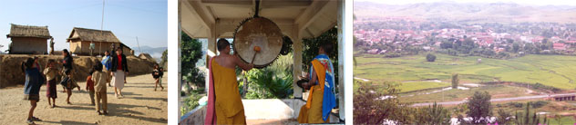
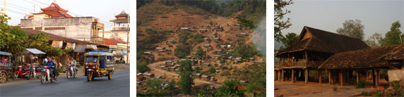
Savannakhet Province is situated in the middle of the country and the largest province (21,774 square kilometers), being bordered by Vietnam to the East, Thailand to the West, Khammouane Province to the North and Salavanh Province to the South. 60% of land is covered by forests. A wide variety of ethnic groups are found in the province: Lowland Lao, Phoutai, Thai Dam, Katang, Mangkong, Vali, Lava, Soui, Kapo, Kaleung and Ta-Oi. In addition, many Vietnamese and Chinese descendants live in the province as well. This fact makes the province rich in cultural and gastronomic diversity.
Savannakhet has long been a center of trade and power. The province is well noted as the birthplace of the Honorable Kaisone Phomvihan, first Secretary of the Lao People’s Revolutionary Party and co-founder of the Lao PDR. His house and a museum documenting his life achievements can be visited in Savannakhet Town. The province’s history, however, goes back long before the time of man.

Savannakhet

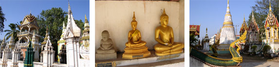
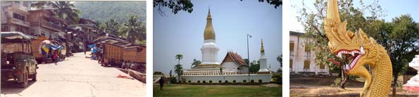
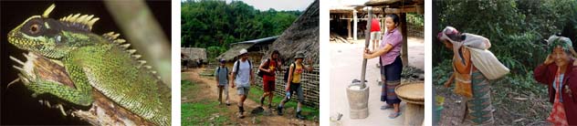
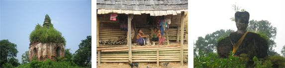
The area was once inhabited by dinosaurs as evidenced by the bones found in Bang Tang Wai Village and the giant footprints found in Phalanxay, which are documented in the Savannakhet Dinosaur Museum. Remnants of an ancient civilization can be seen at the Stone temple, “Heuan Hin” a pre-Angkorian building located 40km down stream from town along the Mekong. That Ing Hang Stupa, originally built more than 1.000 years ago and later rebuilt by King Saysethathirath in the 16th century, is the province’s most important religious site. Also of interest is the historic library, Hortay Pidok, which is believed to have been built in the 18th century and was traditionally used to house old “Bai Lan” Buddhist scriptures. Of more recent history is the section of the Ho Chi Minh Trail which passes through Savannakhet. Old tanks, guns and other war equipment left behind on the trail can be seen near villages on Route 9 near the Vietnam border.The Phouthai ethnic group, known for its unique silk and cotton weaving, claimsits origin in the province’s Vilabouly District. The Katang ethnic group, which is loved for its famous folk song, Lam Tang Wai, also has traditional lands in Savannakhet. For nature enthusiasts, trekking in Dong Phou Vieng National Protected Area (NPA) provides an opportunity to see rare Douc and Silvered Langurs. Phou Xang Hae NPA has a population of wild elephants as well as distinctive rocky outcrops and vistas. The Eld’s deer, once considered to be extinct in Laos, were rediscovered in 2002 in Xonbouly District and are revered by local villagers. The Province is a hot spot for crocodiles, which inhabit the confluence of the Champhone and Xe Bang Hieng Rivers. Hundreds of stump-tailed macaques, considered sacred by locals, are easily spotted in the 4-hectare Monkey Forest. Giant Asian soft shelled turtles, also considered sacred, can be easily seen in Ban Done Daeng. In Dong Na Tad Provincial Forest, snakes, monkeys and old-growth forest are well protected by the villagers for spiritual reasons. Locally guided tours to the area are available.

Savannakhet is most noted for its weavings, especially Phouthai silk and cotton weaving in Vilabouly District, and ethnic Katang weaving in the Dong Phou Vieng area. The favorite national meat, “sin savanh”, a flat, sweet dried beef sprinkled with sesame seeds, originates from Savannakhet and can be purchased in local markets.

The That Ing Hang Festival is the largest festival of the year and is typically celebrated in December at the time of the full moon.

Source: www.tourismlaos.org

Other provinces, see more at:

CENTRAL OF LAOS

Central of Laos has 03 provinces: Savannakhet, Khamouane and Bolikhamxay. To explore those provinces, read more at:

Khammouane at a glance

Located: in the middle part of Laos (Central Provinces)
Total area: 16,135 square kilometers
Population: 375,504
09 Districts: Thakhaek, Mahaxay, Nongbok, Hinboun, Nhommalath, Bualapha, Nakai, Xebangfai & Xaybouathong
Capital of the province: Thakhaek
Khammouane is located in central Laos bordering Bolikhamxay and Savannakhet Provinces. Khammouane covers about 16,000 square kilometers and has a population of approximately 330,000, mostly engaged in agriculture. The Mekong River Valley in the west is framed by the Annamite Mountain Range which separates Khammouane from Vietnam to the east.
The Limestone Mountains are honeycombed with countless caves, some of which for ages concealed forgotten treasures. The Buddha Cave (Tham Pa Fa) was just discovered in 2004 and houses 229 priceless Buddha images. Kong Lor Cave is perhaps the most well-known in the province. It is 7.5 km long and as high and wide as 90-100 m in some places. The province has three national protected areas (NPA) that cover an enormous area about 6,295 km2 in total. Phou Hin Poun NPA encompasses much of the limestone Forest and has 43 recorded species of bats.

Khammouane

The Hin Namno NPA is located in the area where the Central Indochina Limestone meets the Annamite Chain, and as a result, has prominent limestone escarpments and caves. The most important area in terms of biodiversity. However is the Nakai-Nam Theun NPA with its complex range of habitats and newly discovered species of mammals such as the saola, giant muntjac, and Indochinese warty pig.Locally made products include handmade incense sticks, naturally dyed cotton and silk weavings produced in the Kong Lor area. The province’s favorite snack, khaonome parn, is a soft sticky green and black colored sweet wrapped in banana leaves made with yellow soy beans and coconut in the middle. This treat was originally brought to Laos generations ago by Vietnamese settlers. Today, whenever Lao people visit Khammouane they are obliged to bring back a bag of khaonome parn to their friends and family.Fertile land here is well suited to plantations of rice, cabbage, sugar cane, bananas, etc. A total population is made up of lowland and up-land Lao groups: Phuan, Tahoy, Kri, Katang etc. Thakhaek is the provincial capital, situated across the Mekong from Nakorn Phanom in Thailand. It also has much well preserved French colonial architecture similar to that found in Vientiane.

Inhabiting mainly lowland river valleys the Lao, Phouthai and other Tai-speaking peoples are the main ethnic groups in Khammouane. There are also Mekong or Bru people, a Mon-Khmer-speaking ethnic minority that make up 13% of the provincial population. In smaller numbers are the Kri, Nguan, Atel, Themarou, and Maleng who are mainly found in the mountainous eastern part of the province.
The vast forsest of the Nakai-Nam Theun National Protected Area are an important watershed that feed many Mekong tributaries as well as form the catchment area for Nam Theun 2, the largest hydropower project in Laos.

Source: www.tourismlaos.org

Other provinces, see more at:

CENTRAL OF LAOS

Central of Laos has 03 provinces: Savannakhet, Khamouane and Bolikhamxay. To explore those provinces, read more at:

Luang Namtha at a glance

Located: Northwestern Laos (Northern Provinces)
Total area: 9,325 square kilometers
Population: 164,310
05 Districts: Namtha, Muang Sing, Muang Long, Viengphoukha & Nalae
Capital of the province: Namtha
Tucked in the northwestern corner of Lao PDR, Luang Namtha covers an area of 9,325 square kilometers with more than 85% of its terrain being low calciferous mountains that rise to between 800 – 2,000 meters above sea level. The highest point (2,094 masl) is found in Vieng Phoukha District and several peaks that approach 2,000 meters can be found among the province’s central mountains that separate Namtha and Muang Sing. Like the rest of the country, Luang Namtha’s weather pattern is characterized by a rainy season lasting from May to October followed by a cool dry period from November to February. March and April are the hottest months. On average, daily temperature is a pleasant 25 degrees Celsius but during the cool season it can dip to zero on the coldest nights.

Luang Namtha
To the north, Luang Namtha shares a 140 kilometer land border with the People’s Republic of China and its northwest frontier with Myanmar follows a 130 kilometer stretch of the Mekong River. Administratively, Luang Namtha Province is divided into 5 districts including Namtha, Nale, Vieng Phoukha, Long and Sing (Muang Sing) that are further divided into 380 village units. The provincial capital, which is also called Luang Namtha, is in Namtha District and is the most heavily populated town with nearly 45,000 inhabitants. Total population in 2005 was 145,310 with 78% classified as rural and 40% less than 14 years old.
Luang Namtha’s main industries are agriculture, wood processing, lignite and copper mining, handicraft production, transportation and tourism. In 2005 per-capita GDP stood at US$ 280 and grew at an annualized rate of 7.7%. In terms of employment, most people are engaged in agriculture, planting rice, corn, vegetables, cassava and peanuts. Other important agricultural products are buffaloes, cattle, fish, chickens, rubber, teakwood, watermelons, sugarcane and peppers. Forest products such as bamboo shoots, mushrooms, rattan, cardamom and ginger are also key sources of income for the rural population.

Highlights in Luang Namtha
That Phoum Pouk
This stupa is located At Nam Ngaen village on a hill in the northeast part of the Namtha valley. The original stupa was constructed in 1628 to demarcate a neutral territory between the Kingdoms of Lane Xang (centred in Luang Prabang) and Lane Na (centred in Chiang Mai). This peace was shattered in 1966, with the old Stupa destroyed by a bomb unceremoniously released from a US warplane. The new monument, which sits besides the older, ruined stupa, was constructed in 2003.
Meuang Sing museum
The Meuang Sing museum focuses on local cultures and history and has an excellent collection of historically and religiously significant pieces located on the top floor. The building was once the royal residence of the Chao Fa, Phaya Xekong.
Open 9:00am-11:30am, 1:30pm-3:30pm, Monday-Friday. Admission 5,000 kip (plus 5,000 Kip extra for Akha film).
Namha National Protected Areas
An Asean Heritage Site on an area of 2,224 square kilometres, the protected area is primarily mixed deciduous forest. It is located about 26km from Luang Namtha town. The top of this range is mainly dry evergreen forest and some grassland. Three large rivers drain catchments southward to the Mekong, being the Nam Tha, Nam Fa, and Nam Long.
The forest is abundant with significant mammals, including the clouded leopard, leopard, and tiger.
There are small populations of gaur, Asian elephant, and a possibly unique muntjac species.
Namha National Protected Areas is available for ecotourism activities such as trekking, river rafting, camping, kayaking, bird watching, mountain bike tours, and village homestays.
About 6 km northeast of the town centre of Namdee village is an excellent place to observe the progress of bamboo papermaking.
Behind the village, you will see the entrance to the Nam Dee Waterfall.
The area around the waterfall offers excellent facilities, like a small handicraft shop managed by the villagers; toilets and a covered rest area for picnics.
The Phieng ngam handicraft village and the Nam Ngaen Lao Rice whiskey distillery village
These two villages provide homes to members of two ethnic groups, the Thaidaeng and the Thaikhao, respectively. The villages are famous for their many different handicrafts. A small lodge built by the Namha Ecotourism Project offers accommodation for anybody who is interested in experiencing the rural Lao lifestyle. Within walking distance from Pieng Ngam village is the Lao-Lao liquor distillery in Nam Ngaen village, where people can see the process for making the famous Lao rice whiskey.
Night market
The newly renovated night market is located in the centre of Luang Namtha town, where local villagers from many different ethnic minorities offer unique handicrafts for sale. The night market opens every evening and is a good place for eating typical Lao dishes and when the chance arises, witnessing dance and music performances.
Food
A popular local food is Khao soi (soft rice noodle soup), considered by some to be the most “Lao” of the noodle soups. The name, which means “rice cut”, was derived from the process of noodle-making. The rice noodles are made by cutting a rice pancake into strips with scissors. The highlight of the dish though is the soupy broth, made with a mix of pork chop and partially termented soybeans. Versions are available in all restaurants and markets.
Sing district is particularly known for its fine Khaosoi. To see the production process, try Ban Siliheuang in Thaineua village, located on the road to Xiengkok 2km from the town centre.
Accommodation

More than 530,000 tourists visited Luang Namtha last year. About 220,000 people have already visited the province in the first six months of this year. There are more than 100 hotels and guesthouses. The province has 123 tourist sites, including 53 natural tourism sites, 56 cultural tourism sites and 14 historic sites.
Shopping
Luang Namtha province has many kinds of goods available for shoppers, especially a variety of handicrafts made by hand by craftspeople of different ethnic minorities. There are also beverages such as Lao Hai (rice wine in a jar) and Lao Lao from the distillery in Ban Nam Ngaen village, where people can also see the process of making the famous Lao Rice whiskey.

How to get to Luang Namtha
Luang Namtha is accessible by air, land and river. It is about 700 km from Vientiane by road and can be reached by bus from the Northern Bus Terminal in Vientiane. There is an international border crossing at Boten to China and regular air services take around an hour from Vientiane.
For adventurous travellers, try a journey up the Mekong River from the village of Huayxai to Xiengkok in Long district, or a 2-day river journey up the Namtha River, which also originates in Ban Huayxai. Once you reach the province, local transport by tuk-tuk, bus or jumbo-taxi is inexpensive and easy to arrange. In town and around, many people get around by renting bicycles.

Source: www.tourismlaos.org

Other provinces, see more at:

Sayabouly>>

Huaphanh>>

Oudomxay>>

Bokeo>>

Phongsaly>>

Phongsaly at a glance

Located: in the northern part of Laos (Northern Provinces)
Total area: 16,270 square kilometers
Population: 176,151
07 Districts: Phongsaly, May, Khua, Samphanh, Boun Neua, Boun Tai & Gnot-Ou
Capital of the province: Phongsaly
Farthest north in Laos is Phongsaly, which shares borders with Yunnan (China) and Dien Bien (Vietnam). Most of Phongsaly Province lies at a high altitude. Its capital, Phongsaly town, is the highest city in Laos PDR at 1.400 m above sea level. Up there the climate is pleasant and refreshing covering the endless mountains down to the canyon of the Nam Ou River, biggest tributary of the Mekong. The population is made up of officially 28 different ethnic groups, of which the majority being Khmu, Phounoy, different Akha, Tai Lue and Hor, each with their own culture, traditions, costumes, and languages. The forests contain an abundance of animal, bird, insect and plant life, and there are certainly many undiscovered species, new to science. Several trekking tours have been established by the Provincial Tourism Office Phongsaly.
Most visitors of Phongsaly Province get a feeling of “no longer being in Laos, not yet having reached China”. History tells fascinating stories, though much of it still lies in darkness. Between China and Laos the territory of north-western Phongsaly and southern Yunnan once was the independent Tai Lue kingdom of Sipsongpanna. In 1895 the French colonialists drew new boundaries along the watersheds of the Nam Ou river, claiming Sipsongpanna’s eastern part to Phongsaly incorporating it into French Indochina. Its bigger part went into Yunnan Province, China.

PhongsalyUnless many other cities in Laos, Phongsaly Town has not been destroyed in the American war. It features a remaining old quarter with Yunnanese wooden architecture now rare to find in Yunnan itself. Most of the people living here belong to the Hor ethnic group, speaking Chinese. Until the 1970s there has been a Chinese consulate in Phongsaly Town, now the “Phou Fa Hotel”. In the “Museum of Ethnic Groups in Phongsaly Province” you can admire the various local cloths, artifacts and handicrafts. The town itself is surrounded by rolling hills and is built into the side of Phou Fa Mountain (1,625m). The 45 minute hike up to its stupa on top offers spectacular views of the town from above and the mountains in the far distance.
Although a bit off the main tourist circuit, visitors can spend plenty of time in Phongsaly Province trekking to remote villages around the provincial, Boun Neua, Muang Khua at the Nam Ou River and in Boun Tai District’s “Nam Lan Conservation Area”. In the northern most district of the country, Gnot Ou, visit Wat Luang, a magnificent Tai Lue style Buddhist monastery dating back to 1445 AD. In the future “Phou Den Din National Protected Area” along the border with Vietnam will be opened for boat trips. Wild animals like monkeys, elephants and tigers still claim it their territory!
The province offers a delicious variety of Lao and Yunnanese cuisine that consists of wild forest ingredients such as fragrant herbs, bamboo and rattan shoots. After dinner try a shot of the local Lao Lao, smooth, strong and tinted green! During the final stage of the distillation process this rice whisky is running over fresh picked raspberry leaves absorbing the green color.
Chinese-style green tea of Phongsaly receives worldwide recognition for its highest quality and superb taste. Tea leaves are picked by Phounoy minority women from up to 400 year old tea trees, standing 6m high with a stem up to 30cm in diameter. These precious tea leaves are compressed in bamboo cylinders and sold in cigar-shaped tubes. In this wild tea grove fertilizers and chemicals have never been used. Drinking a daily cup keeps the body in good health, reduces fat and preserves a clear mind.

Source: www.tourismlaos.org

Other provinces, see more at:

Sayabouly>>

Huaphanh>>

Oudomxay>>

Bokeo>>

Luang Nam Tha>>

Bokeo at a glance

Located: in the northwestern of Laos (Northern Provinces)
Total area: 6,196 square kilometers
Population: 165,661
05 Districts: Houai Xay, Ton Pheung, Meung, Pha-Oudom & Paktha
Capital of the province: Houai Xay
Bokeo, meaning ‘gem mine’ is the smallest province in Laos, but one of the most ethnically diverse with over 30 recognized ethnic groups. The Lahu, a Tibeto-Burman speaking people common in northern Myanmar and Thailand are present in Bokeo in significant proportions. The province is located in the heart of the infamous “Golden Triangle” sharing borders with Luang Namtha as well as Myanmar and Thailand. Houai Xay, just across the border from the Thailand of Chiang Khong is a popular starting point for boat trips down the Mekong to Luang Prabang, a two-day journey south.

Bokeo descriptSince ancient times Houai Xay, the provincial capital, has been the disembarkation point for travellers and traders from Yunnan Province in southern China on their way to Thailand. It is still a popular town for trading in Chinese goods. Wat Jom Khao Manilath, a teak Shan-style pagoda built in 1880 houses a stele that dates back to 1458. Fort Carnot, a remnant of the French colonial period is still standing but off limits to visitors, as today the fort is occupied by the Lao army. Just south of the main town it is possible to visit one of the main sapphire-mining areas in Indochina.
For the energetic visitor or for those heading up to Luang Namtha, stop in Vieng Phoukha to organize a one, two or three day guided trek to local Khamu, Lahu and Tai Lu villages. In the Nam Kan Provincial Protected Area one of the few remaining populations of Black-cheeked Crested Gibbons can be found, singing their eerie and beautiful early morning songs during the cold season from November-February. If you are interested in archaeology visit the ancient city of Souvannakhomkham near Ton Pheung District just north of Houai Xay.
River trips to the far north can be arranged from Houai Xay, either on the Mekong or the smaller Namtha. River travel north on the Mekong terminates at Xieng Kok in Luang Namtha, where you can then easily proceed overland to the historic town of Muang Sing. The two-day journey up the Namtha requires an overnight stay in your boatman’s village, a memorable experience for those seeking an off-the-beaten path adventure.
Swimming in the Mekong near Houai Xay is the largest freshwater fish in the world, the famous Mekong catfish known locally as “paa beuk”. This giant grows up to 3m in length and can weigh up to 300 kg. The meat of this enormous but endangered fish is considered a delicacy and brings a high price in markets as far away as Bangkok.

Source: www.tourismlaos.org

Other provinces, see more at:

Sayabouly>>

Huaphanh>>

Oudomxay>>

Phongsaly>>

Luang Nam Tha>>

Oudomxay at a glance

Located: in the northern of Laos (Northern Provinces)
Total area: 15,370 square kilometers
Population: 299,935
07 Districts: Xay, La, Namor, Nga, Beng, Hoon & Pakbeng
Capital of the province: Xay
Tranquil, beautiful and sometimes hidden in the clouds, Oudomxay is located in the heart of northern Laos and is one of the most accessible of the far northern provinces. The rugged mountainous landscape has peaks up to 1.850 m covered in varying forest types and widen fields. The province’s three main rivers are Nam Ou, Nam Beng and Nam Tha, Oudomxay is mainly populated by the Khmu, Hmong and lowland Lao, with a total of 23 ethnic minorities, each with their own languages, cultural heritage and lifestyles.
In Muang Xay, the provincial capital, visit the Chinese market next to the Kaysone monument to see a variety of local products from Oudomxay as well as imported Chinese goods. Take a walk outside of town to see That Phouxaya a top the mountain overlooking Xay for a birds-eye view of the surrounding valley.
The countryside around Xay has several beautiful natural features to visit, including Tad Lak Sip-et (kilometer 11 waterfall) set in a stunning limestone environment, and the peaceful Houay Nam Kat Waterfall. Chom Ong Cave is situated 45km from Oudomxay near the Khmu village of Chom Ongthai. Entering the cave you can follow the spring of the Nam Kaeng River for 1.600m passing through large halls with heights of up to 35m and widths of 20m. Visit the therapeutic baw nam hawn (hot springs) on the road to Phongsaly in Muang La to soothe aching muscles, or the Singkham Buddha Cave that was used to safeguard historical arte facts during the war. Ban Na Xieng Di has some interesting archaeological sites believed to date back about 500 years. Also unique is the Buddha footprint or phabath found in Bang Nong Nha.

Oudomxay
Pakbeng, located at the confluence of the Beng and Mekong Rivers is set on a scenic curve of the Mekong shrouded in green mountains. Explore Pha Ho-Pha Hong Cave in Beng District, or experience the shared Lao and Chinese heritage at Ban Theio or Ban Nam Xeng. Visitors can spend time in La District trekking to minority villages in remote and picturesque locations. If you are in Oudomxay during December inquire about the dates of the annual Hmong and Khmu new years celebrations, colorful festivals that include music, trade fairs and lots of local food and drink.
Oudomxay Province is famous as one of the places where ancient bronze drums were cast, which have been a symbol of status and wealth for centuries. Master drum makers continue to make these beautiful drums and purchasing a new drum supports this disappearing cultural heritage. Ban Bo village is well known for skilled handicraft production, especially rattan and bamboo basket weaving. Other quality local handicrafts include cotton weavings and shoulder-bag production, salt making, mulberry paper and silk products.

 Source: www.tourismlaos.org

Other provinces, see more at:

Sayabouly>>

Huaphanh>>

Bokeo>>

Phongsaly>>

Luang Nam Tha>>