


Total area: 7,665 square kilometers.
Population: 97,900.
04 Districts: Lanarm, Kaleum, Dakcheung and Thateng.
Capital of the province: Lanarm.
Sekong is situated in the southern of Laos. Bordering provinces with Vietnam to the east, Champasack Province to the west, Salavanh Province to the north and Attapeu Province to the south.Sekong, the best known for the Bolaven Plateau is situated in the heart of the southeastern part of Laos; Sekong province is rugged, wild and very scenic, but transportation is very difficult, especially by land in the rainy season. Dotted through out are villages and small towns; such as Lave, Lanam, Kaleum, Dakchung and Thateng, where the majority of people follow and the unchanging lifestyle of traditional farming. Overall, the Sekong river valley is characterized by a landscape of a fertile plain patterned with a patchwork of rice paddies and fruits orchard. It’s also a complex geographical conditions form colorful Eco-Tourism resources because it’s famous by rich of untouchable tropical forest, home to many rare species of flora and fauna.
Sekong Province is one of the least explored provinces in Laos due to the rugged landscape and mountainous terrain that rises to the Dacheung Plateau. With 14 distinct ethnic groups belonging to the Mon-Khmer linguistic family this sparsely populated province is probably the most ethnically diverse in southern Laos. The Katu and Talieng are the largest ethnic groups in the province and are noted for their unique religious practices that mix animism and ancestor worship.
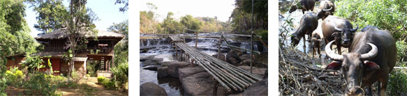 The Sekong River, which bisects the province flowing south into Cambodia is ideal for river trips. Local boatmen hire long-tail boats for scenic river journeys that follow the edge of the Bolaven Plateau down to Attapeu Province. Occasionally, freshwater dolphins migrate up the Sekong right up to Sekong Town. The province is dotted with many cascading waterfalls. Tad Hia, Tad Faek and Tad Se Noi (or Tad Hua Khon) waterfalls are the most convenient to visit from town and offer opportunities for swimming, trekking and village visits. Another waterfall not to be missed is the Nam Tok Katamtok, which originates from the Huay Katam River deep in the jungles of the Bolaven Plateau.
Xe Xap National Protected Area, which covers an area of 1,335 km2 straddling Sekong and Salavanh provinces includes part of the southern Annamite Mountains and is mostly steep terrain with high plateaus of about 1.400m. On the eastern and southern sides of Xe Xap steep faces rise from 400m to 1.400m, topped by Dong Be at 2.066m. The protected area’s habitat of hill evergreen, semi-evergreen and pine forests support large mammal species including two types of bear, gaur, dhole, serow, large antlered muntjac and tigers.
Sekong is well known for its unique textile patterns, which consist of multicolored line patterns created from a hip loom. Although many of the groups produce beautiful weavings, the Nge ethnic group is especially renowned for its works, as well as the Alak for their traditional Lao skirts (sin). Handicrafts can be purchased directly from villages, as well as from handicraft shops in Sekong Town (also known as Muang Lamam). In Kandone Village there are excellent examples of woodcarvings and traditional longhouses.
If you are in Sekong during January – February inquire about the fascinating annual festivals held in Katu, Nge and Tariang villages. Another notable local celebration is Boun Suang Heua (traditional boat racing) that takes place in Sekong on 2 December every year to coincide with Lao National Day.
Source: www.tourismlaos.org